

Keele neighbourhood plan proposal documents
Keele neighbourhood plan submission
Submission version V4.6, June 2026
Contents
Neighbourhood plan, aims and policies
Introduction
Purpose of the plan
This is a neighbourhood plan for Keele neighbourhood area (see figure 1). It contains planning policies for the parish. The plan seeks to support growth, including ongoing development of the strategically important Keele University campus and science park. At the same time, it seeks to ensure that development is well-designed and to protect the parish’s natural and historic environments.
The neighbourhood plan is based on community and stakeholder engagement, evidence on a range of socio-economic and environmental matters and analysis of local issues. These provide the foundations for the planning policies.
Status of the plan
The Keele neighbourhood plan, once made, forms part of the statutory development plan, together with the adopted Newcastle under Lyme Borough Council local plan. Section 38 of the Planning and Compulsory Purchase Act 2004 requires planning applications to be determined in accordance with the policies of the statutory development plan, unless material considerations indicate otherwise.
The neighbourhood plan will be in force from the date it is made until the end of 2035.
The neighbourhood plan does not deal with excluded matters, including waste, mineral extraction or nationally significant infrastructure.
Implementation, monitoring and review
The neighbourhood plan will be used by the local planning authority as a basis for decision-making through the development management process. Similarly, the plan would be used by the Planning Inspectorate in considering appeals.
The neighbourhood plan will be used by Keele Parish Council as a basis for decision making in the development management process. Keele Parish Council will use the neighbourhood plan as a basis for making representations on planning applications and appeals.
The plan will be monitored to assess its effectiveness. Also, changes in national planning policy, local planning policy and local circumstances will be assessed. The neighbourhood plan will be reviewed and updated as and when necessary.
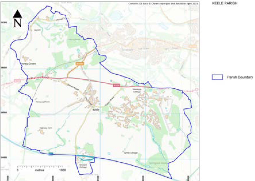
Figure 1: Keele Neighbourhood Area
Background
The neighbourhood area
Strategic context
The parish of Keele lies approximately 3 miles west of Newcastle-under-Lyme in North Staffordshire, and is part of the borough of Newcastle–under-Lyme in the West Midlands region, as shown in figure 1 above.
The parish
The parish covers an area of approximately 775 hectares, and is comprised of the village of Keele, the outlying hamlet of Finney Green and the Keele University campus.
It is a largely rural area with much agricultural land and includes a range of natural assets and habitats including woodland and meadows. The parish is characterised by the natural landscape with extensive views towards Cheshire in the north and the Shropshire and Welsh hills to the west.
The predominant employment opportunities in the parish include Keele University, agriculture and the livery stable. In addition to these there are a number of small businesses and services run from home within the parish and The Sneyd Arms public house.
Keele is a picturesque rural parish, and the centre of the village is a conservation area, with fine examples of Victorian architecture, including The Sneyd Arms. The parish also includes a range of heritage assets with several Grade II listed buildings, including the Grade II* Church of St. John, the spire of which is visible from afar and Grade II* listed Keele Hall with its historic parks and gardens.
The first records of Keele are of King Henry II granting the manor to the crusading Order of Knights Templar in the 12th century, and this period is remembered by Knights Croft (a road off Quarry Bank Road) and by the wrought iron sculptures at the Newcastle end of the bypass.
From the 16th century Keele was in the hands of the Sneyd family and the village is an excellent example of a "closed" estate village, that was inextricably linked with the Keele estate. Although ownership of the estate moved from the Sneyd family to the University of Keele a strong relationship still exists, with Keele University being the only university in the UK to be named after a village.
Population
The 2021 Census recorded 360 households with a population of 2,900 in Keele. Over 74% of the population is in the 15-29 age group and reflects the high student population within the parish. There are more people working from home in comparison to the average in England with 36.5% mainly working from home across the parish.
Community and stakeholder engagement
Community engagement activities
- Formation of a Keele Neighbourhood Plan group with members of the community, Keele University and Keele Parish Council: May 2016
- Creation of an email circulation list: June 2016
- Production of Keele Neighbourhood Plan Website: June 2016
- Creation of a Keele Neighbourhood Plan Facebook page: June 2016
- Drop in events for the community: November 2016
- Initial Meetings with local businesses and school: November 2016
- Initial questionnaires to the community: Feb 2017
- Initial questionnaires to students at Keele university: May 2017
- Ongoing updates in Parish Council newsletter, Facebook, website and bulletin: ongoing
- Options consultation events: Jan 2018
- Consultation on local green space designations with the community and landowners: June 2021
- Direct mailings to residents and local businesses
- Stakeholder consultation for regulation 14: February 2021
- Residents’ consultation for regulation 14: February-March 2021
- Use of Parish Council noticeboards, University and local business locations to display posters advertising g events, including regulation 14 consultation: ongoing
Key issues in responses to community engagement
- Preserving the rural character and historical assets of the parish
- Preventing excess housing development and maintain protection offered by Greenbelt from urban sprawl
- Preservation of existing green space and historic parks and gardens
- Reducing traffic congestion, speeding and encouraging sustainable transport
- Improving public transport links by increasing number of destinations buses go to
- Illegal parking
- Improvement of local shops
- Improved community facilities
- Development of children’s play area in within Keele village
- Provision of a range of housing to maintain a diverse community. This should include social housing and smaller dwellings to allow for young people and for downsizing
- Improvement to broadband
Issues raised
Our consultation events and questionnaires gave consistent signals with regard to the direction our plan should take. All residents, including the student population commented on how much they enjoyed living in a rural setting and the historic parks and gardens of the University Campus. They also enjoyed the strong sense of community, access to facilities on campus, the quietness and the diversity of people living here. People were concerned that excessive development should not threaten the special characteristics of the parish.
There was an understanding that some local housing would be a good thing, especially to cater for the needs of young people and our aging community. It should be noted that since our initial questionnaire and consultation events, more than 90 new homes have been developed on the Hawthorns site in Keele Village. Another 100 homes are in development on land north of Pepper Street.
The campus now has a dedicated post office and a well-stocked supermarket. The village hall was taken under new management and a much greater range of community events were offered and considerable work done on restoring the hall. Open Reach have greatly improved broadband in the parish and mobile phone signals have been improved.
National policy context
The Neighbourhood Plan has had regard to national policy and guidance, including the National Planning Policy Framework (NPPF) December 2024.
Chapter 2: Achieving sustainable development states that sustainable development has economic, social and environmental objectives and this underpins the policies of the Neighbourhood Plan, together with the requirements of Chapter 3: Plan-making. The Neighbourhood plans does not promote less development than set out in the strategic policies for the area or undermine those strategic policies.
Policies related to housing seek to influence the type and mix of homes to support the sustainability of the community, meeting a range of housing needs, taking account of Chapter 5: Delivering a sufficient supply of homes.
The neighbourhood plan supports employment, community facilities and the growth of Keele University Campus, to help create conditions for businesses to invest, expand and adapt, taking account of Chapter 6: Building a strong, competitive economy.
The neighbourhood plan responds to Chapter 8: Promoting healthy and safe communities, by supporting local community facilities and designating spaces with community value as Local Green Space. The Plan places emphasis on active travel, having regard to Chapter 9: Promoting sustainable transport.
Neighbourhood plan policies also deal with design, character and climate change, having regard to Chapter 12: Achieving well-designed places, Chapter 14: Meeting the challenge of climate change, flooding and coastal change and the National Design Guide (2021).
Neighbourhood plan policies also seek to protect, preserve or enhance the rural and historic environments, in response to Chapter 15: Conserving and enhancing the natural environment and Chapter 16: Conserving and enhancing the historic environment.
Collectively, the neighbourhood plan policies address the economic, social and environmental objectives for sustainable development.
Local policy context
Adopted local plan
Local strategic policies are contained in the local development framework, Newcastle-under-Lyme and Stoke-on-Trent core spatial strategy, adopted in October 2009.
Whilst it is recognised that most of these policies are out of date, the following policies of the core spatial strategy are of most relevance to the policies in this neighbourhood plan:
- Policy SP1 Spatial principles of targeted regeneration
- Policy SP2 Spatial principles of economic development
- Policy SP3 Spatial principles of movement and access
- ASP4 - Newcastle town centre area spatial policy
- ASP5 - Newcastle and Kidsgrove urban neighbourhoods area spatial policy
- ASP6 - Rural area spatial policy
- Policy CSP1 - Design quality
- Policy CSP2 - Historic environment
- Policy CSP3 - Sustainability and climate change
- Policy CSP4 - Natural assets
- Policy CSP5 - Open space/sport/recreation
- Policy CSP6 - Affordable housing
- Policy CSP10 - Planning obligations
The neighbourhood area, including the historic village of Keele are over washed by green belt. Keele University and part of the Science Park development are removed from the green belt.
Keele village is identified in the hierarchy of centres at the lowest in tier 5 ‘villages’, with a growth strategy of “no further growth is planned in these settlements, and efforts will be made to ensure existing services and activities within these villages are protected”.
However, the reality is far different with approximately 200 new homes granted consent during the preparation of the neighbourhood plan.
There are no strategic site allocations for housing in the neighbourhood area. However, there is a strategic site allocation relating to Keele University and Science Park (allocation E8 employment development).
The core spatial strategy does also recognise that Keele University and Science Park are significant key assets that are driving the local economy, and their future expansion recognised through the strategic site allocation.
The neighbourhood plan policies have been drafted to complement the policies in the core spatial strategy. They include more locally specific detail. In addition, they take account of more recent evidence and also the latest versions of the national planning policy framework (December 2024) and planning practice gidance.
Emerging local plan, Newcastle-under-Lyme Borough Council
The emerging local plan sets the vision for the borough up to 2040, including policies and strategic site allocations. It is at a late stage, now in examination (2026).
Policies relating to strategic sites in the parish include:
- KL13 Keele Science Park Phase 3
- KL15 Land South of A525 Keele
- SP11 (2) Golf course
The parish council have worked closely with Newcastle-under-Lyme Borough Council to ensure there are no disparities between the two plans.
Evidence and planning rationale
Housing
The Keele Housing Needs Assessment prepared by AECOM, August 2017 indicates that “Census data and forecasts spanning the plan period indicate a growth in solo households, and a substantially ageing population.”
It also makes clear that “There has been a sharp increase in the Private Rented Sector (PRS), and this is likely to act as a substitute for affordable housing.”
More recent housing development has included predominantly family homes (3-bedroom +). This means that there is little choice for first time buyers or those seeking to downsize. Anecdotally, there is considerable support and interest for bungalow development.
The emerging local plan identifies a housing need target for Keele Parish of 800 (2020-2040). By March 2025, commitments and completions accounted for 588 of this figure, which included residential development schemes such as the Hawthorn’s and Land North of Pepper Street. The remainder of the figure should be addressed by strategic housing site allocations through the emerging local plan and policy KNP-1 Residential development of this plan which supports development within existing built areas where it comprises infill development for gaps in existing built frontages and/or brownfield sites. This collective approach positively delivers the growth strategy for the neighbourhood area and the housing figure of 800 new homes.
The following figures have been provided by Newcastle-under-Lyme Borough Council.
Approved applications
Application no: 18/00698/FUL
SHLAA reference: KL28, KL29, KL30
Decision date: 22 July 2019
Expiry date: 22 July 2022
Site address: Sites Of Horwood, Lindsay and Barnes Halls. Keele University, Keele, Newcastle Under Lyme, Staffordshire, ST5 5BW
Application description: Demolition of 732 student bedspaces and the erection of 20 new buildings to provide 1,685 student bedrooms (1706 student bed-spaces) and social hubs at Horwood and Lindsay Halls and the provision of car parking at Barnes and Horwood Halls.
Student accommodation: 1706
Local plan allocations
| Site reference | Brief description | Decision date | Expiry date | Total new dwellings proposed (net) |
|---|---|---|---|---|
| KL13 | Local plan site allocation | 26 June 2020 | n/a | 220 |
| KL15 | Local plan site allocation | n/a | n/a | 260 |
Local employment and community facilities
Keele has a range of community facilities. This is clearly a factor in considering new housing development, which generates vehicular journeys to make access to employment and community facilities.
Outside of Keele University and Science Park, the vast majority of Keele Parish is in Greenbelt, so this is recognised in policies relating to housing and employment development and community facilities.
Keele currently has the following services: a supermarket, GP, a pharmacy, coffee shops, restaurants/ cafes, two places of worship, a pub, a village hall, St Johns CE primary school, restaurants, village hall, golf driving range, and a good public transport service.
Design and heritage
Good quality design is a key factor in creating quality of life, including good physical and mental health. The Keele Heritage and Character Assessment prepared by AECOM contains some analysis of the rural and historic character and also principles for development. These have informed the heritage and design policies. The ‘Building for a Healthy Life’ standard and National Design Guide have informed the design policy. The National Trust Guide to Heritage in Neighbourhood Plans 2019 has also been taken into account.
One way of creating more distinctive development, but also recognising the challenges of the current age, would be on supporting the use of natural and local materials.
Climate change provides an important context for the following policies and the Green Guidance Note. These focus on practical ways of addressing carbon use and biodiversity.
The AECOM Keele Heritage and Character Assessment, November 2017 identifies key characteristics of the built and natural landscape of the Neighbourhood Area. It notes that:
"Natural England defines key characteristics as “those combinations of elements which help to give an area its distinctive sense of place” that would result in significant consequences for the current character if they were changed or lost. As a result, they form important evidence to support the development of planning and management policies and a reference point against which to monitor change.
The key characteristics of Keele are as follows:
- predominantly pastoral farmland setting with mature field trees, fields bound by hedgerows, and areas of woodland
- nucleic development of settlement with a clear defined settlement edge and centre at Keele village
- high quantities of hedgerows and lack of hard boundary treatments to residential properties within Keele centre
- distinctive stone walls on the main roads into Keele village
- the distinctive architecture of properties along The Village with characteristic elements including fish-scale tiles, elaborate chimneys, dormer gables, and red/brown brick construction with blue brick detailing
- buildings displaying architectural influence of the Sneyd family (the RS monogram being the most distinctive)
- prominent use of distinctive architectural elements including tiles, brick patterns etc.
- Keele village’s historic location at the entrance to the Sneyd estate revealed by the tree-lined avenue, open space and clustering of listed buildings at the east end of the village and
- Keele Parish Church, which forms a local landmark"
(Pg 18, Keele Heritage and Character Assessment, November 2017, AECOM)
The neighbourhood area includes 2 conservation areas:
- Keele conservation area, designated in 1989 (with Article 4 Direction)
- Keele Hall conservation area, designated in 1993
The Keele conservation area appraisal and management plan, December 2017 identifies the key characteristics of the area, including the rural and informal organic layout of the historic village. The larger open areas on the edges of the settlement and landscape character where hedges, shrubs and trees make a significant contribution to the character and appearance of the conservation area. The character appraisal concluded that the retention of the landscape character and mature trees and hedgerows, protecting architectural features on buildings and the historic sandstone walls along the village was critical.
Keele has 27 listed buildings and monuments, mainly Grade II, but both Keele Hall and St John's Church are Grade II*. The oldest building on the list dates from the 17th century, and the newest building is the Keele University Chapel built in the mid-1960s. Much of Keele University's grounds are also registered as historic parks and gardens.
In addition to nationally listed buildings, Keele has 24 buildings that are considered to be of local importance, which appear on the borough council's local list. In addition to this, the stone walls and wrought iron sculptures in the parish are on the local list.
Keele Parish contains a number of working farms which fall within Staffordshire County Council's definition of an Historic Farmstead. These include Lower Hill Farm, Top Farm, Honeywall Farm and Highway Lane Farm. There are also historic farm buildings which have been repurposed to either residential or business uses whilst preserving the buildings e.g. Keele Farmhouse, Home Farm and Upper Farm.
The area, such has below ground archaeology, and the Staffordshire Historic Environment Record shows a possible Roman road, the earthwork remains of medieval field systems, and historic mineral railway remains. There are already national policies and guidance and local plan policies relating to archaeology.
Countryside and environment
A rural parish, the natural environment has shaped the landscape and informed the historic development of Keele as a hilltop settlement. Landscape character is of
significant importance to the parish.
The DEFRA Magic Map shows the Neighbourhood Area includes a range of natural assets and priority habitats. These include:
- ancient woodland
- areas of high groundwater vulnerability
- open mosaic habitat
- priority habitat deciduous woodland
- priority habitat wood pasture and parkland
- priority species - curlew and
- priority species - lapwing
The natural environment contributes to creating quality of life, including good physical and mental health. Important local green spaces are designated in the plan.
As previously discussed, the landscape character has been identified as a key feature of both conservation areas. The AECOM Keele Heritage and Character Assessment, November 2017 supports this noting the characteristic landscape features of the Neighbourhood Area that include:
- strong ridge and valley landform
- low intensity pasture farming
- intact hedgerow pattern
- dry stone walls and stone buildings
- hedgerow trees and extensive tree canopy along streams
- hedgerow field pattern with mature hedgerow oaks and some ash
- broadleaved woodland
- pronounced rolling landform
- parkland and pasture farming and
- isolated properties
Transport and infrastructure
The neighbourhood plan seeks to promote active travel, as an important part of creating walkable and sustainable neighbourhoods. Active travel includes walking, cycling and wheeling.
Staffordshire County Council adopted a new local transport plan (LTP) in January 2026 which is supported by the bus service improvement plan (BSIP) and local cycling and walking infrastructure plan (LCWIP).
Keele University
Keele is an unusual parish as the University and Science Park dominate a large section of its eastern fringe. As a result, the number of residents varies considerably throughout the year, increasing significantly during university semesters when students are in residence.
We are well served by public transport due to the proximity of the university, and the campus provides facilities for the village and surrounding areas, including shops, cafes, a bank, a post office and a GP on the university campus.
The Keele University ‘Estate Strategy and Masterplan’ updated October 2022 sets the strategic vision for the Keele University campus and the science park. There are 9 strategic priorities including a coherent campus with a strong sense of place, establishing a ‘green campus’ that maximises the natural and rural setting and being climate resilient. It also sets out the vision of how to further support active travel and more sustainable modes of transport.
The masterplan concept includes intervention areas where development and regeneration will be focused in the next 10-years, development guidance and design principles, and a movement network, which includes creating high quality public realm, streets and spaces.
Other factors
The Environment Agency has indicated that parts of the parish are flood zone 1.
The Coal Authority’s records indicate that within the Keele Parish neighbourhood area there are recorded coal mining features present at surface and shallow depth including: mine entries, coal workings and reported surface hazards. These features may pose a potential risk to surface stability and public safety. United Utilities Water has indicated that building over or in close proximity to a water main will not be allowed. A new building erected over or in close proximity to a public sewer or any other wastewater pipeline would also not normally be allowed.
Neighbourhood plan, aims and policies
Planning aims
The Keele neighbourhood plan has the following aims:
- to support proportionate housing development, to meet local need
- to support a range of community facilities and employment opportunities
- to ensure that development is sustainable and well designed
- to reinforce the rural and historic character of the area
- to support opportunities for sustainable and active travel
- to support the development of the Keele University Campus, whilst managing impacts on the wider parish
Achieving the aims
The aims are translated into the following planning policies in this chapter:
- KNP-1: Residential development
- KNP-2: Residential mix and affordable housing
- KNP-3: Employment
- KNP-4: Community facilities
- KNP-5: Sustainable design and character
- KNP-6: Keele village conservation area
- KNP-7: Keele Hall conservation area and historic park and garden
- KNP-8: Rural and natural environment
- KNP-9: Landscape setting and coalescence
- KNP-10: Local green space
- KNP-11: Sustainable transport
- KNP-12: Keele University campus
KNP-1: Residential development
In addition to any allocated sites, housing development will be supported within existing built areas where it comprises infill development for gaps in existing built frontages or brownfield sites, providing:
- it would complement the existing townscape character, including maintaining typical gaps between properties
- there would be no significant harm to the amenity of neighbouring properties in terms of overlooking and loss of light
- both existing and new dwellings would have adequate garden space, taking account of the existing character of gardens in the area
- gaps between properties would be sufficient to allow access for maintenance
Interpretation
The policy addresses both character and amenity for infill development. Infill is the redevelopment of buildings or development of gaps in existing built frontages. Brownfield sites are previously developed land. The policy should be applied closely with the design policy, in addition to other relevant policies.
Adequate garden space is not defined in terms of area, but gardens would need to be sufficient to support normal garden activities such as play, sitting and eating out, plant or food growing, and drying of clothes.
KNP-2: Residential mix and affordable housing
Residential development of three or more dwellings should include a mix of accommodation to meet local need, based on the latest evidence available, and including:
- smaller accommodation (one and two-bedrooms) for first time buyers and people looking to downsize
- dwellings designed for older people and people with limited mobility
Affordable housing provision should:
- where possible be provided as an integral part of the development, of similar design and specification to market housing or
- where this is not possible, be provided in close proximity to the site or elsewhere in the Keele neighbourhood area
Interpretation
The policy augments local plan policy on housing mix (HOU2 in the current local plan). The policy does not set specific proportions for housing mix, so does allow for flexibility. However, it makes clear that one or two bedroom units should form the largest part of the mix.
The policy does not modify local plan requirements in terms of the thresholds or amount of affordable housing required. The policy augments local plan policy, by setting requirements for where and how such provision is made.
The policy seeks to ensure that affordable housing is of similar quality to market housing, rather than being developed to an inferior specification.
For the avoidance of doubt, this policy and the following policy relates to residential development, but not to student and staff accommodation proposals within the Keele University campus.
Development that includes financial contributions for remote affordable housing, rather than providing affordable within the Keele neighbourhood area, would fail to address the local needs of Keele Parish.
KNP-3: Employment
Development for new employment will be supported in the following locations (see figure 2)
- Keele University Campus, Business and Science Parks
- The Keele Centre, Three Mile Lane
- Keele Service Station
- Garage, Hollywood Lane
Outside of these locations, development to diversify existing small businesses or agricultural complexes will be supported.
Support for development under this policy is subject to:
- it not being inappropriate development in the green belt
- there being no significant adverse impacts on the amenities of nearby residential properties by reason of noise, disturbance, dust, vibration or other impacts
- there being no significant adverse impacts on the historic or rural landscape character of the area
Interpretation
The policy supports employment development in use class E. For clarity, it would not relate to industrial development (B2), warehousing and distribution (B8). These would be considered against national policy and Local Plan policies.
The policy would not support inappropriate development in the green belt.
Other requirements for employment-related development, including design and transport, are set out in other policies. Policy KNP-12 sets specific requirements for development of the Keele University campus.
Assessment of impacts on historic or rural landscape character should take account of the Natural England Landscape Character Assessment and any other character assessments for the area. See also policies KNP-8, KNP-9 and KNP-10.
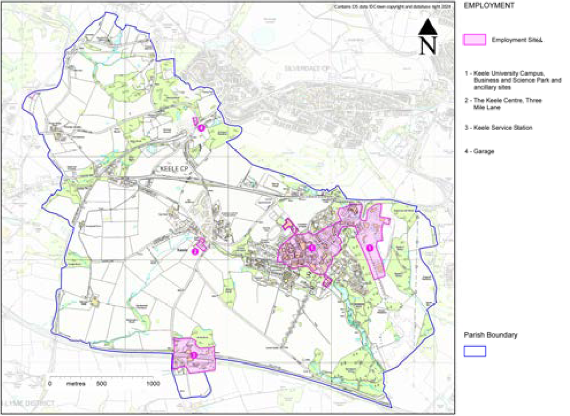
Figure 2: Key Employment Sites
KNP-4: Community facilities
New community facilities, or the diversification of existing community facilities will be supported, providing there is no significant adverse impact on:
- the amenities of nearby residential properties by reason of noise, disturbance, dust, vibration or other impacts
- the historic or rural landscape character of the area
Loss of community uses, will be resisted unless it can be demonstrated that the use is no longer viable, or similar or better facilities are being provided in close proximity.
Interpretation
The policy seeks to protect and retain existing community facilities, but also to create flexibility to allow diversification, to help make them more viable. Community facilities include sports, meeting, recreational and other facilities.
Key local facilities with community value include:
- Keele Village Hall, Highway Lane
- The Sneyd Arms public house, The Village
- St Johns Church, Church Bank
- Keele University chapel (multi-faith)
- The Golf Driving Range, Keele Road
- Various facilities within Keele University campus, including sports facilities, shops, bars, restaurants and cafes, doctors’ surgery, pharmacy and post office
- St John’s Primary School
Close proximity would mean within easy walking distance, without the need for transport. Assessment of impacts on historic or rural landscape character should take account of the Natural England landscape character assessment and any other character assessments for the area. See also policies KNP-6, KNP-8 and KNP-9.
KNP-5: Sustainable design and character
Development should be designed for the specific site and context to create a locally distinctive sense of place, and should complement the characteristics of the street and context in terms of scale, height, massing, degree of set-back from the road and any pattern of front and rear gardens.
Development should respond to topography in its form and layout.
Landscape design should be an integral part of the design and layout of development, to support the creation of a high-quality environment; including:
- taking opportunities to provide tree lined streets
- integrating the design of green spaces and soft landscape design with sustainable surface water management
The design and layout of development should create an attractive, safe and convenient environment for pedestrians and cyclists, including:
- ease of movement for pedestrians and cyclists in the layout of the scheme
- convenient pedestrian and cycle links to surrounding footpath network, to provide easy movement between the development and the surrounding area
- presenting active frontages (elevations with doors and windows) to street frontages, to provide natural surveillance
The form and layout of development should respond to views towards historic landmarks and landscape, including St John’s church spire.
The layout of built development should provide clear separation between public and private space, in particular in avoiding placing rear gardens adjacent to street frontages.
Development in close proximity to green spaces should take opportunities to enhance and have no significant adverse impact on their green and open character, safety, amenity or accessibility.
Development should use high quality and durable materials with a good standard of finish and support will be given to the use of local materials, recycled materials, low-embodied-energy materials and materials with superior environmental performance.
Development should include positive design features to reduce carbon use and support biodiversity, having regard to the green guidance note in this neighbourhood plan.
Support will be given to creative or innovative design solutions, designed for the specific site and context, including designs that incorporate superior environmental performance.
New homes should include discreetly located and screened storage for bins and recycling, minimising visibility from the public realm.
Development should have no significant adverse impact on surrounding and land and properties by reasons of additional surface water run-off, taking account of topography and impacts on lower-lying areas, and should include sustainable urban drainage and permeable hard-surface areas to allow drainage of surface water.
Interpretation
The application of the policy depends on the scale and nature of development. For example, those parts of the policy that address layout would only apply to development involving the creation of new layout.
Green infrastructure would include landscaped areas, trees and other planting. Blue infrastructure would include waterways, ponds and other water features.
The policy is not intended to suppress creativity or require stylistic copying, but to ensure that new development complements the landscape and built character of Keele. The policy makes explicit that the intention is not to suppress creativity or innovation.
The requirement for landscaping to form an integral part of design and layout is intended to prevent poor quality housing development in particular, for example housing layouts based on highway standards and division into plots, with planting of the leftover bits of land.
The policy gives priority to pedestrians in the design and layout of development, including connections to the surrounding area.
Active Travel Infrastructure should be designed according to Staffordshire County Council’s Local Transport Note LTN1/20.
Active frontages could include doors, windows and balconies. Inactive frontages would include black building elevations or high walls or fences as boundary treatments. The requirement to avoid placing rear gardens adjacent to street frontages avoids the need to place high walls or fences on street frontages (inactive frontages).
Responding to views could include designing development to create streets aligned to sight lines of landmarks.
Responding to topography could include use of stepped roof forms, or allowing elevated views to the surrounding countryside through the layout of development. Landscape design can also include stepped forms, responding to topography.
A green guidance note is included later in this neighbourhood plan.
KNP-6: Keele Village conservation area
Within Keele Village Conservation Area, development should preserve or enhance the character or appearance of the Conservation Area, taking account of the following key characteristics:
- the domestic scale and predominant two-storey height of existing properties, some including dormers in the roof
- the mix of small cottages, short terraces, and detached and semi-detached properties
- properties set back behind front gardens
- verges, hedges and mature trees
- the rural landscape setting
New buildings and extensions should use high quality and durable materials with a good standard of finish, including materials based on the historic palate of materials, including stone, red brick, painted brickwork, render, plain clay or scalloped tiles, timber windows and eaves.
Boundary treatments should complement the historic character, including use of hedges and low stone walls, avoiding open front boundary treatments.
Development should complement and avoid harm to the character of rural lanes, including their narrow verges, hedges and trees.
Interpretation
The policy augments Policy KNP-5, setting additional requirements for Keele Conservation Area. The policy sets out the key characteristics of the Conservation Area as a guide to consideration of whether development would preserve or enhance the character or appearance.
For clarity, the special architectural or historic interest of the Conservation Area is based on the historic village, so consideration of impacts on the character or appearance should be made against that context. The Hawthorns Estate is a recent housing development, so only contributes to the special interest of the Conservation Area in terms of surviving landscape and trees and surviving historic building.
Standard housing estates based on standard highway layouts and standard house types would fail to meet the requirements of policy, especially if loss of trees was involved. Synthetic substitutes for traditional materials should be avoided (such as plastic finished to look like timber).
The Keele Conservation Area Appraisal and Management Plan 2017 may be useful in securing compliance with the policy.
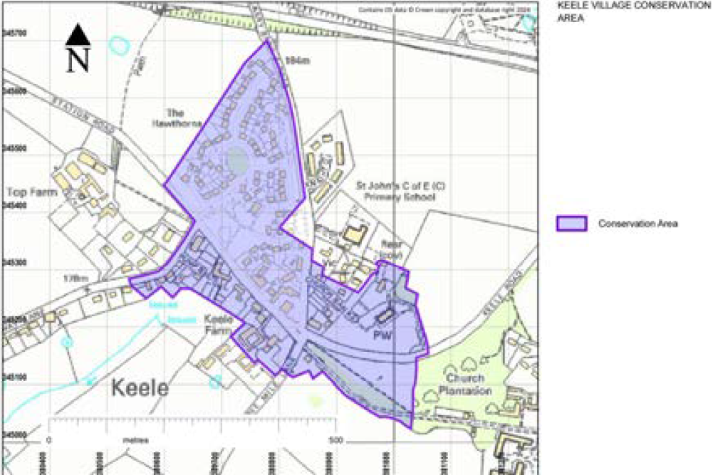
Figure 3: Keele Village conservation area
KNP-7: Keele Hall conservation area and historic park and garden
Within the Keele Hall conservation area and the Keele Hall historic park and garden, development should preserve or enhance the character or appearance of the conservation area and historic park and garden, including preserving or enhancing the following characteristics:
- Keele Hall, the lodges and other historic buildings
- the plan, landscape, gardens, woodland, trees, lakes, stream and pools
- built features including the boathouse, fernery, quarry and viaduct
- historic ground surfaces, including stone seats and gravel walks
Interpretation
The policy augments Policy KNP-5, and also applies together with Policy KNP-12. The wording reflects the special statutory duty for conservation areas in Section 72 of the Planning (Listed Buildings and Conservation Areas) Act 1990. National policy sets out how impacts should be considered and weighed against other public benefits.
The policy would support beneficial change, but requires careful consideration of impacts on the character or appearance of the area. The policy should not be interpreted as a blanket objection to things like renewable energy, providing they are carefully sited and designed.
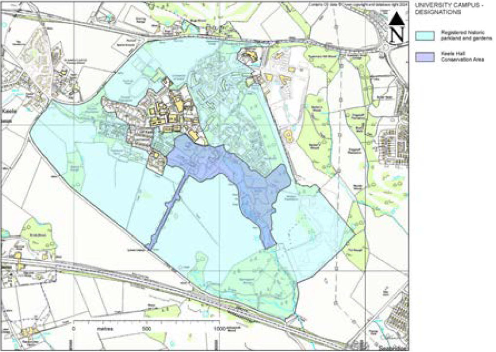
Figure 4: Keele Hall conservation area and historic park and garden
KNP-8: Rural and natural environment
Development should preserve or enhance and avoid significant adverse impacts on Keele’s rural and natural environment, and include mitigation measures where impacts are unavoidable, having regard to:
- landscape character and ecology
- wildlife habitats, including priority habitats
- historic field patterns and traditional stone walls
Development should retain and avoid harm to woodlands, trees and hedgerows, including:
- ancient woodland (Dunge Wood and Hollywood)
- deciduous woodland including Haying Wood, Redheath Plantation, Church Plantation, Bears Rough, Werburghs Wood, Birch Wood and Barkers Wood
- woodlands within the Keele historic wood pasture and parkland conservation area
Where pre-emptive action is taken to remove unprotected trees, hedges or stone walls, reinstatement will be expected as part of any development of the site.
Where development of greenfield land is unavoidable, Biodiversity Net Gain of 20% should be achieved, where possible.
Development should take opportunities to achieve environmental gains such as high-quality landscape design using native species or species with high environmental value and measures to support wildlife.
Development should preserve or enhance water features and their landscape settings, including lakes and watercourses.
Development of historic farmsteads will be supported where it comprises the conversion and proportionate extension of buildings within the existing complex and:
- complements the distinctive built character of the site, with sensitive refurbishment of traditional farm buildings and retention of historic features, including walling, farmyards and external spaces
- where the scheme includes extensions or new buildings, they complement the existing built forms and scale
- the scheme takes opportunities to enhance and does not cause significant harm to the rural and landscape character, including retention of trees and hedges
Interpretation
Priority habitats, identified on the DEFRA magic map, include:
- ancient woodland
- areas of high groundwater vulnerability
- open mosaic habitat
- priority habitat - deciduous woodland
- priority habitat - wood pasture and parkland
- priority species - curlew and
- priority species - lapwing
Measures to support wildlife are contained in the green guidance note, later in this plan.
Tree species in the area are diverse, including lime trees, hawthorns, beech, pear, oak, sycamore, horse chestnut.
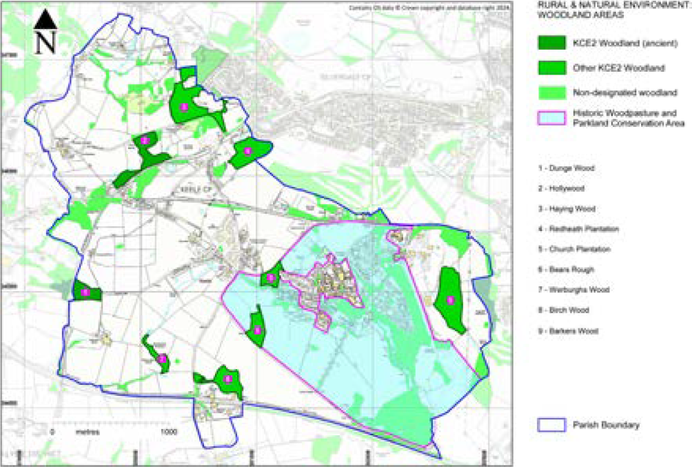
Figure 5: Rural and natural environment woodland areas
The latest information on landscape designations can be seen on the DEFRA magic map.
KNP-9: Landscape setting and coalescence
Development should preserve and not compromise the open landscape setting of Keele Village, including maintaining the green gaps separating Keele Village from the surrounding settlements (see figure 6).
The following areas have particular landscape value as part of the setting of Keele conservation area:
- field adjacent to Keele Road and A525
- field adjacent to Station Road and A525 (the Narley)
Interpretation
The policy recognises the importance of the landscape setting to the distinctive and historic character of Keele Village. The landscape setting is also relevant in the application of special statutory duties for heritage.
For clarity, the policy would not prevent works to the pumping station or to affect permitted development rights in any way.
The green belt status also protects the landscape setting, though this is not an explicit purpose of green belts. So, this policy ensures that the contribution of the landscape setting to historic character is taken into account.
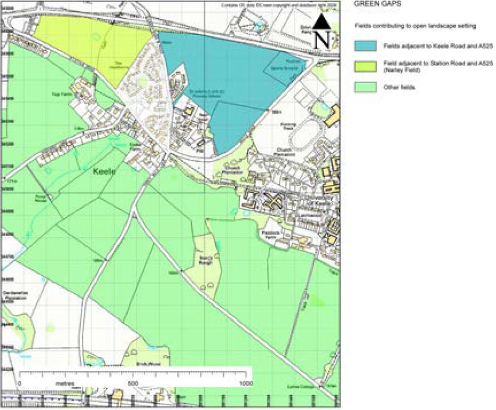
Figure 6: Green gaps
KNP-10: Local green space
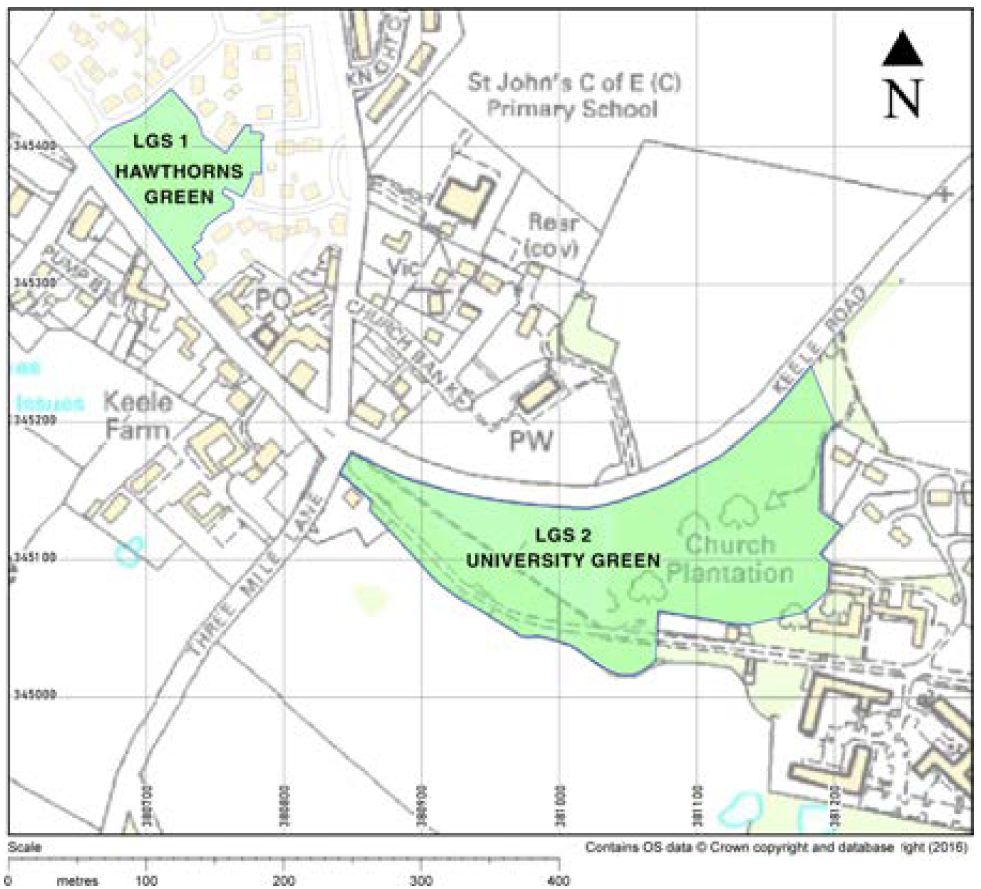
The following spaces are designated as local green space:
- LGS1: Hawthorns Green, in front of Hawthorns House
- LGS2: University Green, Keele Road
Interpretation
The policy designates and protects local green space (LGS). The NPPF states that LGS has similar protection to green belts. However, it should be noted that the purpose of local green spaces in national policy is quite different to the five purposes for green belts.
Figure 7 shows the local green space designations.
KNP-11: Sustainable transport
Development likely to generate additional motor vehicle journeys should:
- be supported by a balanced and sustainable range of transport options and support active travel, proportionate to the scale and nature of the scheme
- where necessary, provide transport improvements, to mitigate impact
Residential development should include:
- secure, covered storage for cycles and personal vehicles for all new dwellings
- adequate off-road parking provision to avoid parking on narrow roads
Development should prioritise pedestrian and cycle convenience, permeability and connectivity and provide connections to allow easy pedestrian and cycle access to surrounding footpaths, bus stops and community facilities.
Development adjacent to or affecting existing footpaths, cycleways, bridleways and other public rights of way should:
- a. incorporate them into the design, layout and landscaping
- b. take opportunities to enhance and have no significant adverse impact on their amenity, safety, accessibility or outlook and
- c. take opportunities to provide new linkages
Commercial development involving the creation of new parking and/or garage facilities should include charging facilities for electric vehicles.
Interpretation
The requirement for transport provision to be proportionate to the scale and nature of the development recognises that some minor developments, with no generation of journeys, would not be expected to address transport provision. Development creating employment space or new dwellings would clearly need to respond, especially schemes creating new road layouts.
The policy should be applied together with Policy KHD1, which also deals with pedestrian convenience.
KNP-12: Keele University estate
Support will be given to the development of the Keele University estate where it accords with the university masterplan and:
- preserves or enhances natural and landscape character of the campus, including, preserving trees, woodland and water features
- complements or enhances the historic character and architectural diversity of the campus and setting of listed buildings
- complements or enhances the public realm in terms of attractiveness, convenience, amenity and recreational use.
Development within the Keele University estate should include balanced transport provision, taking account of additional floorspace and projected increases in demand, to help ensure that it does not have any adverse impact on parking in Keele Village centre, including:
- provision of adequate levels of student, staff and visitor parking
- providing additional, convenient, secure and covered storage facilities for cycles or taking opportunities to upgrade existing cycle storage facilities
- taking opportunities to enhance or create attractive, convenient and safe pedestrian and cycle links through the campus and between the estate and Keele Village
Car parking areas must be designed as an integral part of the design, layout and landscaping of development and include sensitive landscape design and use of permeable and durable surface materials with a high standard of finish.
The creation of multi-level parking will be supported, where it would enhance overall parking provision and/or release existing surface car-parking areas for landscaping and recreational use.
The reversal of previous unsympathetic alterations to designated and non-designated heritage will be supported.
Development that helps to integrate the teaching campus and the science and innovation park will be supported.
Development to expand community facilities within the estate will be supported.
Interpretation
The policy recognises the strategic importance of the estate and ongoing need for growth. At the same time, it recognises the distinctive historic and landscape character of the estate.
The policy augments other policies in the Neighbourhood plan, which also apply to the university estate. To meet the requirements of the policy, it is essential to understands the historic landscape and built heritage context of the site.
To meet the requirements of this policy and other design, heritage and landscape policies of this plan, development within the setting of Keele Hall and the designated Keele Hall historic park and garden should demonstrate very high standards of design, including architecture, urban design and landscape design.
The public realm includes green and urban spaces, landscaping and paths. Car parking is also part of the public realm. The need for well-designed carparking areas could include use of contrasting materials, rather than painted lines.
The policy does not encourage stylistic imitation of buildings, recognising that architectural diversity and innovation and creativity are part of the character.
Particular emphasis is placed on sustainable transport, including careful consideration of transport impacts on Keele Village.
The policy supports reinstatement of historic buildings, where harmful alterations have taken place. This could include the Students Union building, a non-designated heritage asset and good example of post-war heritage (but in a much-altered state), also with group value with the adjacent Grade II* listed chapel.
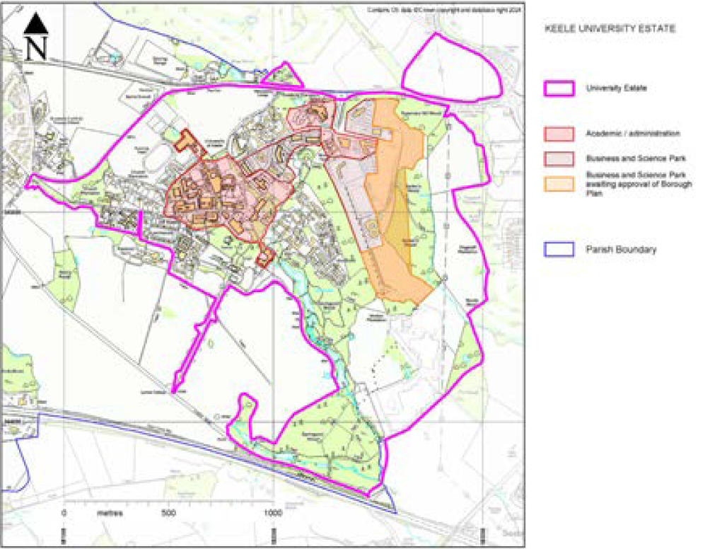
Figure 8: Keele University campus
Green guidance note
Purpose of this green guidance note
This is a guidance note for developers, to help development schemes to address climate resilience and biodiversity. It is an informal note, so includes both planning matters and non-planning matters. However, use of the guidance may help in achieving compliance with the policies of the neighbourhood plan.
Key principles for sustainable development
The following general principles can help to make development more sustainable.
Mixed use
It is important to maintain Keele as a mixed use parish (which include residential properties, employment and community facilities in easy walking distance),reducing the necessity for journeys.
Connectivity
Layouts should prioritise pedestrian and cycle movement, convenience and safety. This includes convenient links to public transport (see policies KNP-5: Sustainable design and character, KNP-11: Sustainable transport and KNP-12: Keele University estate).
Home working
Flexible work practices such as home working or local hot desks can help to create more sustainable live/work patterns. Many meetings can be held through digital media.
Reuse
Retention and reuse of existing buildings preserves the energy embodied in their materials and construction and avoids landfill.
Design for climate resilience
Carbon neutral development should be a key goal in building design. In meeting the requirements of this plan’s design policies, the following ways of building green may be helpful:
- use of efficient heating and cooling systems, or design to reduce dependency on heating and cooling systems
- superior insulation properties and airtightness
- orientation to take account of climate
- natural ventilation and air flow to help avoid over-heating in warmer weather
- use of local, low-embodied energy, recycled and recyclable materials
- living (green) walls or roofs as part of the design
- rainwater capture, storage and reuse (grey water) such as connecting rainwater goods to a water butt or collection of bath water
- inclusion of space for natural drying of clothes
- flexible spaces and layouts to accommodate changing demands
- sustainable urban drainage incorporated into the landscape design
- using permeable materials for hard surfaced areas
- use of traditional hedges for boundary treatments, to create a greener environment
- use of native species in planting, or other species with high environmental values
- local renewable energy schemes such as ground heat pumps, photovoltaics, and other technologies
- micro and domestic energy generation, such as rooftop photovoltaics
- reusing and retrofitting existing buildings to maintain the embodied energy used in their construction, whilst also avoiding landfill
Public realm, landscape and biodiversity
Keele is a rural parish, with sensitive landscapes. Existing landscape features, landform and green infrastructure should be retained and be incorporated into redevelopment and enhanced as far as possible.
In terms of impacts on habitats, the following hierarchy should be used:
- avoid habitat damage
- minimise habitat damage
- restore damaged or lost habitat
- compensate for habitat loss or damage (as a last resort)
Design features to support wildlife include:
- bat boxes and bird boxes (owl, raptors, house sparrow, house-martin, swift, woodpecker)
- hedgehog gaps in fences
- badger routes
- wildlife connectivity via grass verges and footpath edges
- meadow edge grasses and wildflowers, bee friendly desirable
The public realm and green infrastructure should be designed to support movement, recreation, social interaction, play and exercise.
Sustainable drainage systems should be incorporated into the landscape design. This includes green spaces for residential developments.
Hard surfacing should be kept to a minimum area and be water permeable.
Use of traditional hedges for boundary treatments creates a greener environment and enhances the historic and rural character of the area.
Landscape design and planting should use native species or other species with high environmental value.
Useful guidance available online includes:
- Royal Horticultural Society advice guide: Rain gardens
- Raingarden Guide, Bob Bray, Dusty Gedge, Gary Grant and Lani Leuthvilay
- Susdrain web site (including case studies and resources).
Green energy
Local or micro green energy schemes can include small wind turbines, ground heat pumps, photovoltaic and other technologies.Such schemes can impact on the historic and rural character, so the location and design of such facilities requires careful consideration, given the sensitivity of many locations within Keele Parish.
Infrastructure priorities
Use of planning infrastructure monies
This chapter is intended to inform the local planning authority on the parish council’s preferences in the legally compliant use of planning infrastructure monies.
Infrastructure expenditure priorities are:
- improvement of the village hall
- repairs to footways in Keele village and alongside the A525 ‘route to school’ to Madeley
- repairs to dry stone walls around St John’s church and along Keele Road
- installation of fibre to premises broadband
- maintenance of sculpture at entrances to Keele village
- improvement of footpath along Pepper Street to the village
- improvement of drainage capacity on the village
- repair of gates on Quarry Bank Road
- improved drainage from cemetery extension field onto Quarry Bank
- resolution of drainage issues on Station Road
- installation of traffic lights at exit from new housing development on Pepper Street
- improvement of the community orchard