

Keele neighbourhood plan representations
KE5 Asteer Planning, Persimmon Homes

Representations to the Keele Neighbourhood Development Plan Regulation 16 Submission Version
Land to the East and West of Quarry Bank Road, Keele
On behalf of Persimmon Homes North West
Prepared by: Lauren Murphy and Hope Bleasdale
Reviewed by: Jon Power
Asteer Planning LLP, 3rd Floor, Calico, 53-55 Mosley Street, Manchester, M2 3HQ
Version: Final
Date: 25 September 2026
Introduction
The Submission Version Neighbourhood Plan (“Neighbourhood Plan”), as prepared by Keele Parish Council (herein referred to as “KPC” or “the Parish Council”), is out for consultation under Regulation 16, running from 3 August 2026 until 28 September 2026.
These representations have been prepared by Asteer Planning LLP (“Asteer”) on behalf of Persimmon Homes (“Persimmon”) in response to the Regulation 16 Submission Version of Keele’s Neighbourhood Plan, with reference to land to the east and west of Quarry Bank Road, Keele (“the site”) which is under Persimmon’s control and wholly within the Neighbourhood Plan designated area.
The site at Quarry Bank Road extends some 55.25 acres and is situated on either side of the existing Keele Village. The site is characterised by two self-contained parcels of land under single ownership, one to the west of Quarry Bank Road which extends some 22.63 acres; and one to the east of Quarry Bank Road which extends to 32.61 acres. To the immediate north, the site is bounded by the A525 highway, and to the south is the village of Keele. The site is also bounded by existing roads along its eastern (Keele Road), and western (Station Road) boundaries. A Site Location Plan is provided below in Figure 1 and at Appendix 1.
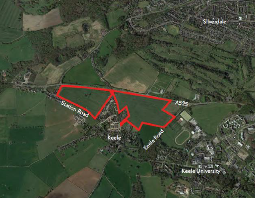
Figure 1: Quarry Bank Road, Keele - site location plan
These representations provide comments on the Neighbourhood Plan spatial strategy, approach to site allocations and development management policies. They also consider the merits of the site, and the benefits that its allocation and development could deliver. An Illustrative Masterplan for the site has been prepared (enclosed at Appendix 2) that demonstrates how the site can be brought forward as a sensitive extension to Keele Village and which can provide benefits and deliver new community infrastructure that will support the needs of the existing community.
Persimmon is fully open to engagement with the Parish Council to better understand the needs of the community.
Structure of these Representations
The remainder of this submission provides:
- Section 2 – Policy Context: sets out the relevant policy context and the basic conditions applied to the making of Neighbourhood Plans
- Section 3 – Comments on the Neighbourhood Plan: providing comments on the Neighbourhood Plan in general and the draft policies
- Section 4 – Land to the east and west of Quarry Bank Road: providing a description of the site context, key environmental and technical considerations, an assessment against Grey Belt criteria, merits of the site, and presents the Illustrative Masterplan for the site
- Section 5 – Summary and Conclusion: providing conclusions and recommendations on the Neighbourhood Plan Consultation
Policy context
National Planning Policy Context
A new National Planning Policy Framework (“NPPF” or the “Framework”) was published on the 17th August 2026, however, as per Annex A, Neighbourhood Plans that have been submitted to the local planning authority under Regulation 16, on or before, 17th August should be prepared in accordance with the Framework published in December 2024. Therefore, the relevant Framework for the Keele Neighbourhood Plan is the December 2024 version.
The December 2024 publication of the NPPF (“NPPF24”) introduced significant changes regarding housing need and housing delivery, including reinstating the requirement for all local planning authorities to demonstrate a five-year supply of deliverable housing land, introducing a new standard method for calculating housing need and introducing the concept of “grey belt”, whereby new homes in the Green Belt may not be regarded as “inappropriate” where they meet specified criteria. These changes have significant implications for plan making and decision making in Newcastle-under-Lyme.
On the 8th July 2026, Newcastle-under-Lyme Borough Council adopted a new Local Plan which forms the statutory development plan against which neighbourhood planning and planning decisions should be considered. These representations will seek to ensure that comments have regard for The Newcastle-under-Lyme Borough Council Local Plan 2020-2040 as the overarching statutory framework for development in Keele, and ensure that they are consistent with any immediate review of the Local Plan (which is required under the transitional arrangements).
In summary, the considerations as they relate to housing and Green Belt for Newcastle-under-Lyme include:
Housing Requirement & Five Year Housing Land Supply
The 2025 Housing Delivery Test identified that between 2024-2025, Newcastle-under-Lyme Borough Council failed to deliver enough housing to meet the number of houses required, measuring at 94%. This emphasises under delivery in the area and a wider need for residential development at local level.
The NPPF24 has increased Newcastle-under-Lyme’s housing requirement from an average of 400 homes per year in the 2026 adopted Local Plan, to 559 homes per year based on the Government’s new standard method for calculating Local Housing Need (“LHN”).
There is now a need for Newcastle-under-Lyme to demonstrate a robust five year housing land supply (“5YHLS”) each year, which will be based on the adopted Local Plan until it is 5 years old (in 2031); at which point it will be based on the Government LHN (currently 559). Based on the Local Plan’s stepped trajectory (of 368 homes per year between 2021-2026 and 400 homes per year between 2026-2031), the annual housing requirement has risen to 400 homes.
In addition to the above, from the 1st July 2026 national planning policy requires local authorities to apply a 20% buffer to 5YHLS for the purposes of decision making, as the housing requirement in the adopted Local Plan makes up less than 80% (only comprises 72%) of the latest LHN figure (as per Paragraph 78c of the NPPF24). The immediate need to demonstrate a 5YHLS, and the potential for a higher housing requirement to be adopted when the Newcastle-under-Lyme Local Plan is five years old, reinforces the need for the Borough to be proactive in ensuring that suitable land and sites are available to meet the Borough’s future housing needs. The consequence remains the same in the new August 2026 NPPF, therefore it will be crucial to maintain a sufficient housing supply.
Green Belt and Grey Belt
In decision making, Paragraph 155 of the NPPF24 sets out that the development of homes in the Green Belt should not be regarded as “inappropriate” where:
- The development would utilise grey belt land and would not fundamentally undermine the purposes (taken together) of the remaining Green Belt across the area of the plan
-
There is demonstratable unmet need for the type of development proposed (please note: in the case of criterion b, for applications involving the provision of housing, this means the lack of a five year supply of deliverable housing sites or where the Housing Delivery Test was below 75% of the housing requirement over the previous three years)
-
The development would be in a sustainable location, with particular reference to paragraphs 110 and 115 of this Framework
-
Where applicable, the development proposed meets the ‘Golden Rules’ requirements set out in paragraphs 156-157 below
There is therefore the potential for grey belt sites to be put forward for development if the land does not undermine the purposes of the Green Belt. Grey Belt is a definition that applies to plan making and decision taking and is defined as land comprising previously developed land in the Green Belt and/or any other land that does not strongly contribute to any of the purposes: (a) to check the unrestricted sprawl of large built-up areas; (b) to prevent neighbouring towns merging into one another; (d) to preserve the setting and special character of historic towns. The Government has released additional detail underpinning its approach to Green Belt and Grey Belt Assessment in Planning Practice Guidance (“PPG”) (dated 27th February 2025). The concept of Grey belt and the Green Belt PPG are now also enshrined in the new 2026 NPPF.
In the context of the Keele Neighbourhood Plan and its relationship to the Newcastle-under-Lyme Local Plan, it is likely that the identification of Grey Belt land will need to be considered to meet the increase in housing requirement, especially in settlements such as Keele where part of the Borough’s strategic policy focus is on expanding Keele University and the Science Park, in the order of 800 new homes. The assessment contained within Section 4 of these representations sets out how the land at the east and west of Quarry Bank Road fully meets the criterion for Grey Belt.
Persimmon request that the Neighbourhood Plan recognises the most up to date national policy including Grey Belt, which is currently omitted from the draft Regulation 16. This approach ensures Keele Neighbourhood Plan is policy compliant and provides opportunity for forms of development to be considered that is not essential to the purposes of the Green Belt, and is in alignment with local priorities.
The Legislative and National Policy Context for Neighbourhood Plans
As outlined within Planning Practice Guidance (“PPG”) under Ref 41-065-20140306 Paragraph 65, only a draft neighbourhood plan or order that meets each of a set of basic conditions can be put to a referendum and be ‘made’. These are set out within Paragraph 8(2) of Schedule 4B to the Town and Country Planning Act 1990, as applied to neighbourhood plans by section 38 of the Planning and Compulsory Purchase Act 2004 as amended by Section 99 of the Levelling Up and Regeneration Act 2023. The basic conditions are:
- Having regard to national policies and advice contained in guidance issued by the Secretary of State it is appropriate to make the order (or neighbourhood plan)
- Having special regard to the desirability of preserving any listed building or its setting or any features of special architectural or historic interest that it possesses, it is appropriate to make the order. This applies only to Orders
- Having special regard to the desirability of preserving or enhancing the character or appearance of any conservation area, it is appropriate to make the order. This applies only to Orders
- The making of the order (or neighbourhood plan) contributes to the achievement of sustainable development
- The making of the neighbourhood development plan would not result in the development plan for the area of the authority proposing that less housing is provided by means of development taking place in that area than if the neighbourhood development plan were not to be made
- The making of the order (or neighbourhood plan) does not breach, and is otherwise compatible with, EU obligations
- Prescribed conditions are met in relation to the Order (or plan) and prescribed matters have been complied with in connection with the proposal for the order (or neighbourhood plan). These conditions relate to the merits of the Conservation Habitats and Species Regulations 2017, and EIA development
At this stage - given 2) and 3) don’t apply to the making of a Neighbourhood Plan - the key basic conditions against which a draft Neighbourhood Plan may be assessed for conformity are 1), 4) and 5). In this regard and as set out throughout these representations, it is important that the Neighbourhood Plan seeks to complement and not be contrary to the adopted Local Plan.
This point is reinforced by Paragraph 31 of the NPPF24 which states (Asteer emphasis in bold):
Once a neighbourhood plan has been brought into force, the policies it contains take precedence over existing non-strategic policies in a local plan covering the neighbourhood area, where they are in conflict; unless they are superseded by strategic or non-strategic policies that are adopted subsequently.
Therefore, if the policies within the Keele neighbourhood plan are conflicting with the adopted Newcastle-under-Lyme local Plan, the latter will effectively override or require the neighbourhood plan to be reviewed or updated.
Comments on Keele draft neighbourhood plan
This section sets out Persimmon’s comments on the Submission Version Keele Neighbourhood Plan, and the detailed policies which seek to ensure that the Neighbourhood Plan is consistent with national policy.
Procedural Comments
As set out in the previous section, Newcastle-under-Lyme Borough Council adopted the Newcastle-under-Lyme Local Plan 2020-2040 in July 2026. In the context of this, it is crucial that the Neighbourhood Plan remains in general conformity with the strategic policies of the adopted Local Plan as per NPPF24 Paragraph 31. This is one of the “basic conditions” under Schedule 4B of the Town and Country Planning Act 1990.
Under Schedule 4B of the Town and Country Planning Act 1990, in line with “the basic conditions’ the plan must also “not have the effect of preventing development from taking place which (i) is proposed in the development plan, and (ii) if it took place would provide housing”. As such, the Neighbourhood Plan should not undermine or prevent residential development that comes forward.
Comments on Draft Policies
Policy KNP-2: Residential Mix and Affordable Housing
Policy KNP-2 requires that residential development of three or more dwellings should include a mix of accommodation to meet local need, including affordable housing provision. Persimmon are in support of this policy, and in compliance with this policy and national standards, as the site proposal would offer at least the minimum level of affordable housing and further support to the housing needs of the Borough. If fully developed, the land to the east and west of Quarry Bank Road could offer up to 435 high-quality dwellings, with both family and affordable housing provision.
Policy KNP-3: Employment
Policy KNP-3 relates to employment development in Use Class E (i.e. does not relate to industrial, warehousing or distribution uses) and states that development for new employment will be supported however only in a number of specific locations and in certain circumstances.
Persimmon consider that the policy wording of Policy KNP-3 should be amended to provide greater flexibility for small scale employment development with Use Class E where this is associated with and would support the delivery of sustainable development. Persimmon’s illustrative masterplan for the site, enclosed at Appendix 2, identifies the potential for a new local shop. Whilst such a use would not fall within one of the locations identified under Policy KNP-3, it could provide a valuable local service for existing and future residents, reducing the need to travel and contributing to the vitality and sustainability of Keele Village. Such provision would also help to ensure that the proposed development on the site is appropriately supported by local facilities and services.
Persimmon therefore requests that Policy KNP-3 is amended to include support for small-scale employment development that supports the delivery of sustainable development and contributes to the vitality of Keele Village, subject to there being no unacceptable adverse impacts and the development not constituting inappropriate development in accordance with national planning policy.
Policy KNP-4: Community Facilities
Policy KNP-4 states that new community facilities will be supported, and St John’s Primary School is identified as a key local facility with community value. The delivery of the proposed development is in accordance with this policy, and Persimmon seeks to offer part of their land allocation to expand St John’s Primary School should there be the demand, to ensure there is school capacity for the local population and future generations. This would also underpin the residential growth of the University Growth Corridor. The Illustrative Masterplan (Appendix 2) also sets out the potential for a new retail offering, which is a service that the village of Keele currently does not have provision for. With the closest shop on the Keele University Campus, there is a demonstrable need for a retail offering that is within close walking proximity to support new residents and the existing village.
Policy KNP-5: Sustainable Design and Character
Policy KNP-5 addresses the need for attractive and sustainable development which should be designed for the specific site and context, including a layout which creates a safe and convenient environment for pedestrians. Persimmon support the objectives of this policy and endorses measures for a truly sustainably development which meets the 10 Characteristics of a Good Place as outlined by national government’s National Design Guide and National Model Design Code. In 2020 Persimmon committed to producing a placemaking framework which is in accordance with these design values, and this would be embedded in the proposed development for the site.
Policy KNP-8: Rural and Natural Environment
Policy KNP-8 identifies that potential development should take opportunities to achieve environmental gains, which Persimmon will prioritise as part of the masterplanning. The site is currently arable farmland with limited biodiversity or recreational value; however, the proposed development should provide an uplift to the biodiversity value that significantly exceeds national targets through the creation of new species rich habitats and multi-functional green infrastructure and green corridors.
Policy KNP-9: Landscape Setting and Coalescence
Policy KNP-9 requires development to preserve and not compromise the open landscape setting of Keele Village, including maintaining green gaps and separating Keele Village from the surrounding settlements.
Policy KNP-9 identifies the designation of land around the Neighbourhood Plan area as ‘Green Gaps’, including Persimmon’s site, to the east and west of Quarry Bank Road (as identified in Figure 6 in the Neighbourhood Plan and copied underneath in Figure 2). These green gaps are identified as:
- Field adjacent to Keele Road and A525
- Field adjacent to Station Road and A525 (Narley Field)
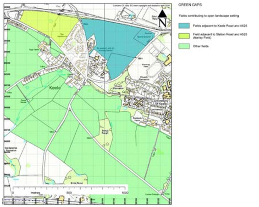
Figure 2: Green Gaps – Keele Neighbourhood Plan Submission Version
Persimmon objects to proposed Policy KNP-9 and consider that the policy, as drafted, is not consistent with the statutory role of a neighbourhood plan or with national planning policy.
The purpose of neighbourhood planning is to enable local communities to plan positively for their areas and to shape and direct development in a manner which supports the wider development plan strategy. The statutory basic condition E specifically requires that “the making of the neighbourhood plan would not result in the development plan for the area of the authority proposing that less housing is provided by means of development taking place in that area than if the neighbourhood development plan were not to be made”. This is particularly important given that the NPPF establishes a clear national objective of significantly increasing the supply of homes and requires development plans to plan positively to meet development needs. It also requires local planning authorities to maintain an adequate and deliverable supply of housing sites.
The introduction of an additional green gap designation which places further policy constraint on land capable of accommodating residential development risks directly undermining these objectives.
The result of the green gap policy is that it may place strain on Newcastle-under-Lyme’s ability to demonstrate a 5YHLS by adding another policy layer to sites that could otherwise achieve significant housing delivery in line with national policy. Accordingly, Policy KNP-9 should be deleted or substantially amended in line with the statutory basic conditions and national planning policy, before the neighbourhood plan proceeds.
Policy KNP-11: Sustainable Transport
Policy KNP-11 states that development should be supported by a balanced and sustainable range of transport options, which Persimmon has regarded as part of the Illustrative Masterplan. There are two key access points to the site; primary vehicular access would be provided on Station Road to the west and via the A525 to the east, whilst further transport opportunities are maximised by providing a network of proposed footpaths and cycleways through the site, connecting open space to the village core and the countryside beyond.
Land to the east and west of Quarry Bank Road
This section provides an overview of the site, the key technical and environmental considerations and presents the Illustrative Masterplan. It also details the significant economic, social and environmental benefits the site could deliver.
Site Context
Land to the east and west of Quarry Bank Road comprises two parcels of agricultural land, totalling approximately 55.25 acres in size. The site is located outside of but adjacent to the existing settlement boundary of Keele Village.
To the immediate north, the site is bounded by the A525 strategic highway, with further agricultural uses and Keele Cemetery located further north. To the west and south west is Station Road, to the south of which is a row of linear residential properties, agricultural land and farm buildings. To the immediate east of the site, beyond Keele Road, is the Keele University Campus, including Keele Sports Centre and its associated pitches. Dissecting the centre of the site is Keele Village (and Conservation Area) which includes some local services and facilities and St Johns CE Primary School.
The site is bounded by hedgerows and sporadic mature trees, and a small pond also is located on the western parcel of the site, to the east of which is an existing public right of way that traverses the site from north to south.
Technical and Environmental Considerations
Highways and Access
The site is in an accessible location with access to existing services and facilities, and with excellent transport connections to Newcastle, Stoke and Crewe.
The site offers access points into both the eastern and western parcels, with the east providing primary access by the A525 Keele Road, and the west access point via Station Road. A secondary access point or emergency access could also be achieved into the site from Quarry Bank Road which bounds the site to the west.
There are 6 bus stops located on Station Road which provide regular services to Newcastle-under-Lyme, Stoke-on-Trent, Hanley and Nantwich, and Stoke-on-Trent train station can be accessed via a 40-minute bus journey.
Access via non-car modes to the services and facilities provided by Keele University Campus is available via existing pedestrian infrastructure on Station Road, all within a 2km walking distance. Keele Village sits adjacent to both parcels, which includes St John’s CofE Primary School and a Public House, which can be reached within a 5–10-minute walk. Appropriate links will be provided from the site into the existing infrastructure and enhanced where necessary.
Ecology
The site is not covered by any designated statutory sites of nature conservation interest, although Keele Village is a designated conservation area which runs adjacent to the site. Given its agricultural use, the habitats within the site are common and are considered to hold limited value and be of negligible ecological importance.
The site is surrounded by roads on all sides and a residential estate to the centre, meaning the opportunities for links to other nearby habitats are therefore also limited. As part of the Illustrative Masterplan, there is the opportunity for a biodiversity enhancement corridor consisting of the existing public footpath, pond and associated trees, which would be incorporated into any future development with appropriate buffers to preserve their value as wildlife habitat.
Overall, given the nature and location of the site, there are no overriding constraints to its development in terms of ecology, and it is considered the site can be delivered in a manner which provides appropriate mitigation and biodiversity enhancement.
Arboriculture
Given the use of the site for agricultural land, it has very limited vegetation other than hedgerows along the boundaries of the site, some dense overgrown hedgerows, and groups of sporadic mature trees within the site.
There are numerous Tree Protection Orders (“TPO”) located along the site boundary of Quarry Bank Road and also along the boundary with existing development in The Hawthorns. There is also one TPO located within the centre of the eastern parcel of the site.
A landscape-led approach to future development will seek to ensure that existing trees, hedgerows, pond and existing landscape elements will be retained and incorporated into the scheme wherever possible. Along with substantial new planting, this would help to ensure that any new development could integrate positively in the surrounding area and offer multi-functional green infrastructure.
Heritage and Conservation
There are no designated heritage assets (Listed Buildings, Scheduled Monuments, Registered Battlefields or Parks and Gardens) on the site. Keele Conservation Area abuts the western parcel of the site and is in close proximity to the eastern parcel and there are a number of designated heritage assets within 1 kilometre of the site, predominantly in the south of Keele Village. This includes a Grade II Listed Church of St Paul the Baptist, and Keele Hall, a Grade II Registered Park and Garden.
Whilst the church spire is seen in some views from the site, there are no views from within the Church towards the site and limited existing views from the burial ground due to tree screening. The eastern parcel is adjacent to the Registered Park and Garden, however it is in close proximity to part of the Park and Garden that has been substantially altered by modern development, and it is anticipated that residential development at the site would have no harmful impact on its heritage significance.
The Illustrative Masterplan (enclosed at Appendix 2) demonstrates a sensitive approach with a high-quality design that holds a defensible boundary and offsetting of development to mitigate any limited impacts to the character and heritage of the location. Such a design approach means the site could retain key views to the key features of the Conservation Area and cause less than substantial harm to its setting.
Flood Risk
The entire site is located within Flood Risk Zone 1, with reference to the Environment Agency flood maps. The closest rivers that are susceptible to fluvial sources of flooding are more than 1.5km from the site to the north and to the south east, and as such the distance and undulating topography means the overall risk of fluvial flooding is considered to be very low. Residential development would therefore be entirely acceptable in line with national guidance on flood risk.
The site and its immediate context are situated on relative high points in the Parish of Keele, and with the topography gently undulating. It is therefore anticipated there would not be any flood risk or drainage constraints preventing residential development on the site.
Utilities
Based on the site’s proximity to Keele Village and Keele University, it is expected that residential development on the site will be able to connect to the existing electricity, water and broadband networks which serve the area. It is therefore not anticipated that there are any significant utility infrastructure constraints, however further assessment would be undertaken to identify any improvement works or on-site provision deemed necessary.
Summary
This section demonstrates the deliverability of the land to the east and west of Quarry Bank Road. To showcase this an Illustrative Masterplan has been prepared which sets out how a development of circa 435 dwellings could be accommodated on the site (Figure 3 below and Appendix 2).
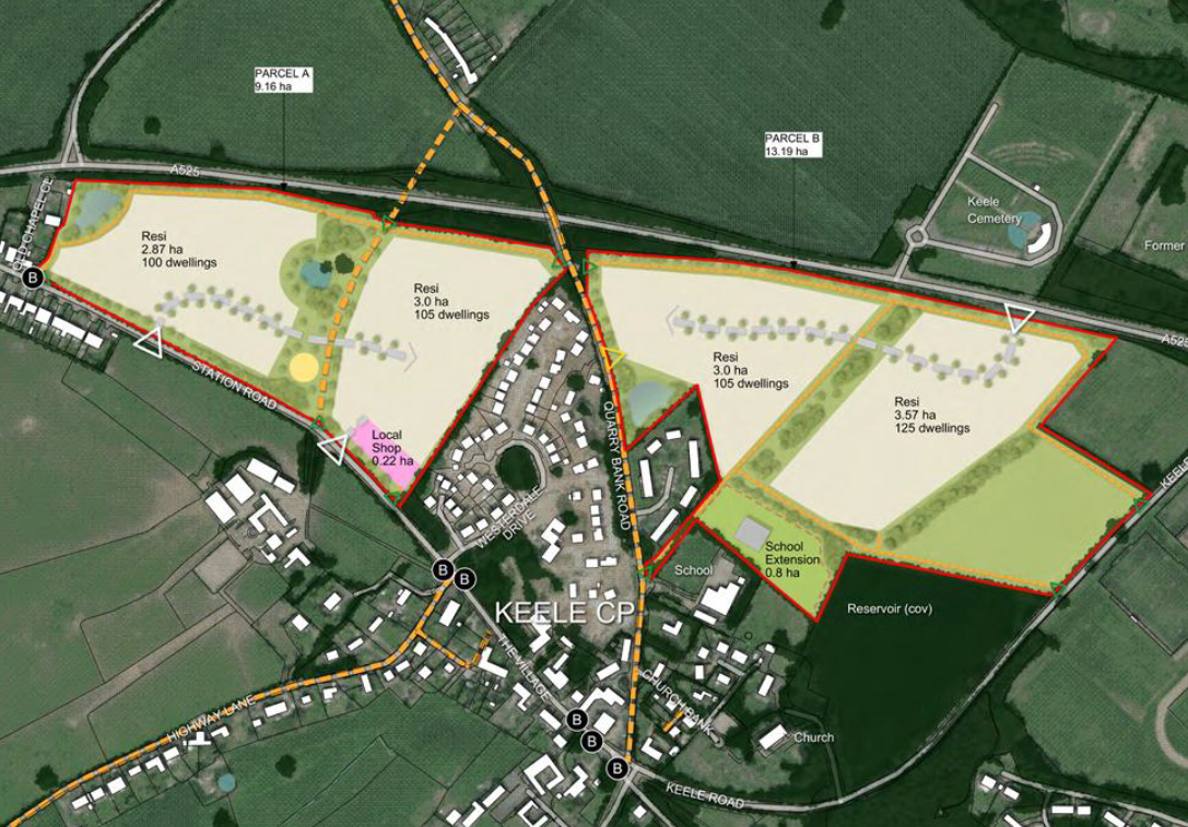
Figure 3: Illustrative Masterplan
Grey Belt Assessment
The site is currently within the Green Belt. The previous Green Belt Assessment (“GBA”) (December 2020) was prepared by Arup as part of the Local Plan evidence base for Newcastle-under-Lyme Borough, prior to the updates to National Policy including the introduction of Grey Belt, and the further guidance released within the NPPG.
NPPF24 and NPPG on Green Belt Assessment, set out the criteria against which to assess whether a site is Grey Belt land. The definition of Grey Belt in NPPF24 is as follows:
For the purposes of plan-making and decision-making, ‘grey belt’ is defined as land in the Green Belt comprising previously developed land and/or any other land that, in either case, does not strongly contribute to any of purposes (1), (2), or (4) above.
The following sets out a high-level assessment of the site against the Grey Belt criteria outlined in Annex 2 of NPPF24, using the more detailed criteria included in the NPPG, to assess whether the site makes a strong contribution to purposes 1), 2), or 4).
| Grey Belt Purpose | The NPPG (Features) | Comments |
|---|---|---|
| Purpose 1 - to check the unrestricted sprawl of large built-up areas This purpose only relates to the sprawl of large built-up areas. Villages should not be considered large built up areas. |
Strong - Assessment areas that contribute strongly are likely to be free of existing development, and lack physical feature(s) in reasonable proximity that could restrict and contain development. They are also likely to include all of the following features:
Moderate - Assessment areas that contribute moderately are likely to be adjacent or near to a large built up area, but include one or more features that weaken the land’s contribution to this purpose such as (but not limited to):
Weak or None - Assessment areas that make only a weak or no contribution are likely to include those that:
|
Keele is a village and therefore, the site has no connection to the Newcastle-under-Lyme urban area and would not have an impact on this purpose. The parcels within which the site sits were also found to make no contribution to this purpose in the GBA (2020). The Site therefore makes ‘no contribution’ to Purpose 1. |
| Purpose 2 - to prevent neighbouring towns merging into one another This purpose relates to the merging of towns, not villages. |
Strong - Assessment areas that contribute strongly are likely to be free of existing development, and include all of the following features:
Moderate - Assessment areas that contribute moderately are likely to be located in a gap between towns, but include one or more features that weaken their contribution to this purpose, such as (but not limited to):
Weak or None - Assessment areas that contribute weakly are likely to include those that:
|
The site is more than 1.8km from Madeley Heath in the west, 1.9km from Newcastle-under-Lyme urban area in the east, and 750m from the urban area of Silverdale to the north. The site therefore does not form part of the physical and visual gap between Keele and neighbouring settlements, and in any case is not a town. The parcels within which the site sits were also found to have a weak contribution to this purpose in the GBA (2020). The site therefore makes a ‘weak contribution’ to Purpose 2. |
|
Purpose 4 - to preserve the setting and special character of historic towns. This purpose relates to historic towns, not villages. Where there are no historic towns in the plan area, it may not be necessary to provide detailed assessments against this purpose. |
Strong - Assessment areas that contribute strongly are likely to be free of existing development and to include all of the following features: Form part of the setting of a historic town Make a considerable contribution to the special character of a historic town. This could be (but is not limited to) as a result of being within, adjacent to, or of significant visual importance to the historic aspects of the town Moderate - Assessment areas that perform moderately are likely to form part of the setting and/or contribute to the special character of a historic town but include one or more features that weaken their contribution to this purpose, such as (but not limited to):
Weak or None - Assessment areas that make no or only a weak contribution are likely to include those that: Do not form part of the setting of a historic town Have no visual, physical, or experiential connection to the historic aspects of the town |
Keele is a village and therefore in accordance with the NPPG, the site would not have an impact on this purpose. The parcels within which the site sits were however found to have a strong contribution to this purpose in the GBA (2020), for reasons including Newcastle-under-Lyme is a historic town, the Keele Conservation Area is located within the Green Belt, and the site would cross important viewpoints. Our assessment considers the site to have a ‘moderate contribution’ to this purpose. The context of the 2020 GBA is fundamentally altered now with the modern Hawthorns development, which alters the setting of the Keele Conservation Area. It is also determined that a scheme which is sympathetic to the surrounding heritage would serve to mitigate any limited impacts and retain key viewpoints. |
In summary, there is clear case for considering the site as Grey Belt, based on a limited to moderate contribution to the purposes of the Green Belt.
Contribution to Openness and the Wider Green Belt
The NPPG (para 64- 001-20190722) states that the ‘openness’ of the Green Belt is associated with both spatial and visual aspects, so consideration of both the visual effects and the volume of built form therein, is usually undertaken when analysing the effects of a development upon the openness of the Green Belt.
The Openness of the Green Belt – Summary
The site itself is self-contained and will provide defensible and permanent boundaries to the wider green belt. Structural planting and a sensitive design will assist in softening new built development. A green buffer particularly along the northern edge of the site will provide further containment of the village from the rural landscape beyond, and therefore any effects upon the openness of the wider Green Belt are expected to be limited.
Merits of the Site
The development of the site for housing would deliver a range of economic, social and environmental benefits.
Economic Benefits
The development of the site for housing would make a positive contribution to building a strong, responsive and competitive economy. The development will secure the following:
- A significant amount of investment generation during the construction phase, through construction costs, FTE construction jobs and an increase in GVA.
- Significant additional spending in the local economy including the services and facilities within Keele Village and Keele University Campus from the site’s new residents which could support full time and part time jobs locally.
- Generation of significant revenue for the Local Authority, including contribution to Council Tax Revenue which will contribute towards funding local services, infrastructure improvements and public realm enhancements.
- Be a catalyst for growth of Keele University and its Science and Innovation Park by providing the quality of housing and community infrastructure that will underpin the retention of graduates and support high value jobs in knowledge left industries.
Social Benefits
The development of the site will have significant social benefits by helping to support a strong, vibrant and healthy community, including:
- Delivering high-quality market homes to meet the needs of Borough’s existing and future employees.
- Contribution to the provision of much needed affordable homes within the borough, to help support housing for graduates, key workers and first-time buyers.
- The creation of significant new green infrastructure and open space and providing land for community use as part of the wider development.
- The opportunity to deliver new community infrastructure such as a retail offering for the village and the expansion of the Primary School, which can meet the existing and future needs of Keele residents.
Environmental Benefits
The development of the site has the potential to significantly uplift the biodiversity, accessibility and overall enjoyment and environmental value of the site, by the following:
- Creation of multi-functional green infrastructure, including green corridors and public open space that can be enjoyed and experienced by both future residents and members of the existing local community.
- Provision of a significant uplift in biodiversity which is well in excess of government targets, and the creation of new habitats for a range of species.
- Enhancement of the existing features of the site that add value, including mature trees, hedgerows and an existing pond.
- Implementation of cutting-edge net zero technologies which are being rolled out by Persimmon through the design, construction and operation of new homes.
Summary
This section has provided a high-level overview of the site to the east and west of Quarry Bank Road, which is being promoted for future residential development. This has demonstrated that the site is suitable for development, and that it can be considered Grey Belt land within the context of the updated national policy context. Furthermore, the Illustrative Masterplan showcases the site’s potential, and a range of compelling benefits it can offer for Keele and the wider borough.
Summary and recommendations
These representations have been prepared by Asteer on behalf of Persimmon in response to the Keele Neighbourhood Plan Regulation 16 Consultation. These representations provide a response to the Neighbourhood Plan specifically in relation to land entirely under Persimmon’s control to the east and west of Quarry Bank Road. A Site Location Plan is enclosed at Appendix 1 and an Illustrative Masterplan at Appendix 2.
The draft Neighbourhood Plan fails to conform to a number of the relevant conditions outlined in Paragraph 8(2) of Schedule 4B to the Town and Country Planning Act. It fails to support and provide for the merits of the relevant national and local policy by allocating no land for housing and further restricting existing land which may otherwise be able to do so by applying additional policy layers.
Based on these representations, it is clear that the Neighbourhood Plan, in order to be sound and to conform with the basic conditions, must take a more proactive approach to addressing the Plan area’s housing and employment needs by:
- Remove the Green Gaps from the ‘Field adjacent to Keele Road and A525’, and the ‘Field adjacent to Station Road and A525 (Narley Field)’.
- Amending Policy KNP-3 to enable more flexibility new employment across the Keele Parish where it would be associated with sustainable development, rather than limit the opportunity for employment and economic growth.
- Acknowledge and be consistent with Grey Belt policy in the NPPF and recognise that the site is a Grey Belt site as set out in high level assessment of the site (Section 4.25).
To summarise, Persimmon are fully committed to delivering high-quality homes and community infrastructure and are committed to robustly demonstrating the merits of the site in line with Regulation 16 Submission Version of the Neighbourhood Plan and the wider development framework of Newcastle-under-Lyme Borough.
Persimmon is enthusiastic about engaging in further discussion with the Parish Council and informing the Neighbourhood Plan as it progresses. We would be happy to provide further information or a meeting on site which can be facilitated by Asteer.
Appendix 1 - site location plan
Quarry Bank Road, Keele - site location plan
Appendix 2 – Illustrative Masterplan
Illustrative Masterplan
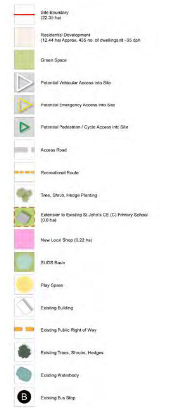
Key for illustrative masterplan